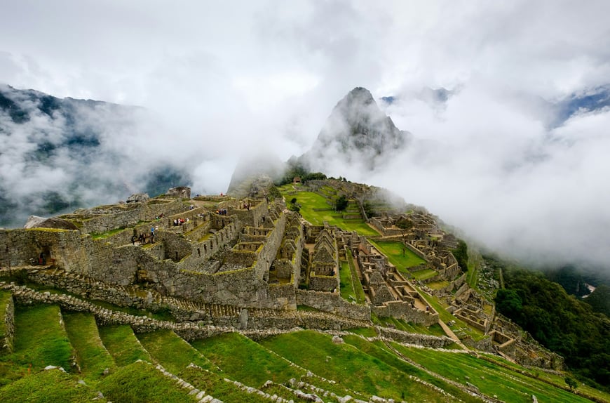
Machu Picchu sits at 2,430 meters on a saddle between the peaks of Huayna Picchu and Machu Picchu, above the Urubamba River canyon in southern Peru. Emperor Pachacuti ordered its construction around 1450, and the royal estate took roughly thirty years to complete. The site holds about 200 structures and more than 700 terraces across 32 hectares. Six centuries of rain and earth tremors have not dismantled what the Incas built without iron tools or the wheel.
This guide covers the engineering choices that kept the site standing. Ashlar stone joints lock together without mortar. Walls slope inward to absorb seismic energy. Terrace fills drain through gravel beds. The piece also walks through the principal religious and civic structures and explains how the Incas planned the city as two halves divided by a natural geological fault.
An Inca Royal Estate at 2,430 Meters
Pachacuti chose the location for several practical reasons. The ridge sat far enough from the imperial capital at Cusco to function as a private retreat, yet close enough that royal couriers could reach it in a few days. The mountain backdrop gave the estate a defensive perimeter on three sides. Tropical cloud forest above the Amazon basin met dry highland slopes here, which let the Incas grow both maize and coca on terraces stacked at different altitudes.
The site never housed more than 750 to 1,000 residents at peak occupation. Most of those were retainers, priests, and craftsmen attached to the royal household. Construction relied on roughly 10,000 laborers rotating through the mit’a system, a state-imposed work obligation that produced everything from terrace stone to thatched roofs. After the Spanish invasion of 1532, Inca occupants abandoned the estate, and the cloud forest swallowed it for nearly four centuries.
Hiram Bingham reached the ruins in 1911 with help from local farmers who had never lost track of the place. His team cleared vegetation, mapped the standing walls, and shipped artifacts back to the United States. Those Yale-held artifacts were repatriated to Peru between 2011 and 2012 after a long legal dispute.
Ashlar Stonework Without Mortar
Ashlar masonry is the defining technique at Machu Picchu. Inca masons cut granite blocks to seat against one another so closely that a steel blade cannot pass between them. They used no mortar at all. The joints rely on contact pressure and friction, with each block trimmed to fit the irregular surfaces of its neighbors.
Two grades of ashlar appear on the site. Coursed ashlar uses rectangular blocks laid in regular horizontal rows and shows up in the Temple of the Sun and other elite structures. Polygonal ashlar uses larger irregular blocks of mixed shape and size, joined along sinuous seams that interlock like a jigsaw. The famous twelve-cornered stone in Cusco is the textbook example, but Machu Picchu has its own polygonal walls in the agricultural sector and around the Royal Tomb.
Walls slope inward by roughly five degrees from base to top. This batter, combined with the lack of rigid mortar, lets the stones flex slightly when seismic waves pass through. During an earthquake the blocks lift, settle back into place, and resume bearing load. Surveys after the 1950 Cusco earthquake found that few Inca walls failed, while colonial masonry built on top of Inca foundations cracked or collapsed. The same pattern applied along the main visitor circuit of the citadel after subsequent tremors.
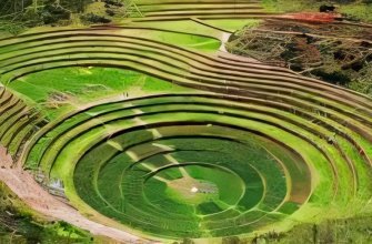
Andenes: The Terrace System
Around 700 terraces, called andenes in Quechua, ring the southern face of the ridge. Each one is a stepped platform held in place by a stone retaining wall about two meters tall. The terraces convert a 30-degree slope into farmable land, give the slope structural reinforcement, and route rainfall through the substrate rather than over the surface.
Cross-section excavations show three layers inside each terrace fill. The base is coarse rubble and broken stone, which lets water percolate downward without saturating the upper soil. A middle layer of sand and fine gravel filters silt out of the runoff. The top 20 to 30 centimeters is dark organic topsoil hauled up from the Urubamba valley floor. This layered approach is the same principle modern civil engineers use for highway subgrade drainage.
The Incas grew maize, potatoes, and quinoa on the lower terraces. Higher elevations carried hardier crops like tarwi and oca. The agricultural sector covered about 4.9 hectares and produced enough food for the resident population, with surplus stored in qollqa warehouses cut into the colder upper slopes. Yield estimates assume average conditions in the surrounding Urubamba valley; bad seasons would have triggered grain shipments from imperial stores at Cusco.
Temple of the Sun and Solstice Alignment
The Temple of the Sun, called Torreon by archaeologists, occupies a platform above the Royal Tomb in the urban sector. It is the only round structure on the site. The walls curve to follow a natural granite outcrop that forms the floor and partial back wall of the chamber. Total interior area is about 50 square meters.
Two trapezoidal windows pierce the eastern face. The northeast window aligns with the June solstice sunrise; on that morning, light passes through the opening and falls on a carved altar at the center of the floor. The southeast window aligns with the December solstice. These dates governed the agricultural calendar across the empire and determined when the planting and harvest festivals took place.
Stonework here is among the finest at Machu Picchu. Coursed ashlar blocks form the curved wall in pre-cut courses that taper to follow the curvature. Drilled jamb holes on the north door once held wooden bars or hinges. Researchers think the room functioned as both observatory and sanctuary, with the Inti Raymi solar festival linking astronomical observation to imperial religion. The connection to Inti, the sun deity, places the temple at the center of Inca religious practice.
Intihuatana: Carved Granite Sundial
The Intihuatana is a single piece of granite shaped into a stepped pillar with a vertical gnomon at the top. The name translates as “hitching post of the sun” in Quechua, a reference to the ritual of symbolically tying the sun to the stone at the solstices to keep it from disappearing. The stone sits on a terraced hill reached by 78 carved steps from the main plaza.
The four corners of the central prism point to the cardinal directions. Each face also tracks specific solar angles. At noon on the equinoxes, the sun stands directly above the gnomon and casts no shadow, a configuration the Incas used to verify their calendar. Similar Intihuatana stones existed across the empire, but Spanish priests destroyed most of them during the colonial period as part of the campaign against Inca religion. The Machu Picchu example survived because the Spanish never found the site.
Visitors can no longer touch the stone. Peruvian authorities cordoned it off after a 2000 advertising shoot damaged a corner of the gnomon when a crane fell on it. A more detailed examination of the carving sits in the dedicated post on the Intihuatana stone.
Royal Tomb Beneath the Temple
The Royal Tomb is a chamber carved into the natural cave formation under the Temple of the Sun. The interior holds three trapezoidal niches, an altar shaped as a three-step staircase known as the chakana, and walls of fitted ashlar that meet the natural rock at the back. Despite the name, archaeologists have found no human remains inside.
The chakana motif appears throughout Inca religious sites. The three steps stand for three planes of existence: the heavens, the world of the living, and the underworld. The carved altar inside the Royal Tomb is one of the cleanest examples of this iconography in surviving Inca architecture. Some researchers suggest the chamber once held the mummified remains of Pachacuti himself before they were moved during the abandonment of the site.
The cave entrance opens through a carved doorway with finely cut jambs and a triangular lintel. Inside, the ceiling is the underside of the granite outcrop above. The combination of natural rock and worked masonry is typical of Inca sacred architecture: the Incas treated certain stones and outcrops as huacas, sacred objects in their own right, and built around them rather than reshaping them.
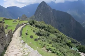
Urban, Agricultural, and Sacred Sectors
The site divides into two broad halves separated by a long open trench called the dry moat. This trench follows a natural geological fault that runs roughly north to south through the ridge. The fault gave the Inca planners a structural seam to work with, and they used it as the boundary between the agricultural sector to the southeast and the urban sector to the northeast.
The urban sector subdivides further. A sacred zone around the Temple of the Sun, the Sacred Plaza, and the Intihuatana occupies the western edge. The Royal Quarter sits next to it and once held the Sapa Inca and his family. Workshop, residential, and storage buildings cluster on the eastern side closer to the lower entrance. The Main Plaza separates the sacred and residential blocks and served as the gathering space for ceremonies.
The agricultural sector contains the terrace fields, qollqa storehouses, and outlying field-watcher posts. A guardhouse on the upper terrace gives a panoramic view of the whole site and probably functioned as both observation point and customs checkpoint for goods entering the citadel. Visitors today follow a circuit that crosses both sectors and approximates the route a 15th-century resident would have taken to move between fields, residence, and temple. Background on daily life at the citadel sits in the basic facts overview.
Springs, Channels, and Drainage
Two natural springs above the citadel supply most of its water. Engineer Kenneth Wright traced the primary spring to a fault zone in the granite about 700 meters north of the urban core. From there, a stone-cut canal drops at a constant 3 percent gradient into the city and feeds a chain of 16 fountains. The first fountain, closest to the royal quarter, served the Sapa Inca; the rest stepped down to the lower town.
Drainage handles a separate engineering problem. The site receives 1,940 millimeters of rain in an average year, almost all of it concentrated in a five-month wet season. Water that does not enter the spring system has to leave the site without saturating the terrace fills or undercutting the foundations. About 130 outlet drains punch through retaining walls at calculated points, and the layered terrace fill carries subsurface water down through gravel beds to those outlets.
Runoff that crosses the urban paths drains through cut stone channels with covered grates. These channels also handled gray water from the residential blocks. The system has not been re-engineered since the 15th century, and it still works during heavy rain. That is the reason the tropical climate has not undermined the foundations the way it has at Petra or Angkor Wat. Visitors arriving from Cusco may also notice altitude effects long before they study the drainage; practical preparation for the 2,430-meter elevation is worth a separate read.
Granite, Pounders, and Wooden Wedges
Local granite supplied most of the building stone. A primary quarry sat just inside the urban sector, and several blocks abandoned at intermediate stages of shaping are still visible there. Limestone appears in some agricultural retaining walls, and sandstone shows up in lower-status structures. Higher-quality blocks for sacred buildings came from the central quarry; coarser fill from peripheral pits.
The Incas had no iron. Stone shaping relied on hammer-stones of harder rock, mainly hematite and basalt cobbles, that masons swung against the granite to chip it into shape. Final fitting used a process modern researchers call “scribing and coping”: a mason set the upper block in place, traced its lower outline onto the block below, lifted it back off, and ground the lower stone to that line. After several iterations the contact surfaces matched.
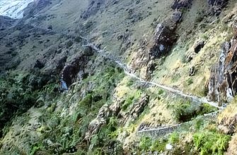
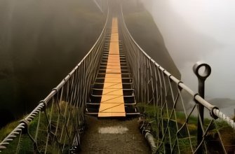
For larger blocks the Incas may have used a wooden-wedge technique. Workers drilled lines of holes into a granite face, drove dry wooden wedges into them, then soaked the wedges. As the wood swelled, it cracked the stone along the drilled line. Move-and-place engineering used inclined ramps, log rollers, and human muscle. The site has no draft-animal evidence; llamas could carry small loads but not multi-ton blocks. Inca engineers also bridged steep canyons elsewhere in the empire, and a surviving example of that work appears in the post on the Inca rope bridge. The largest block at Machu Picchu weighs around 14 tonnes.
Conservation in the Twenty-First Century
UNESCO listed Machu Picchu as a World Heritage Site in 1983 and added it briefly to the World Heritage in Danger list during the 2000s when visitor numbers and uncontrolled access threatened the integrity of the stone. Peru has since restricted daily entry to about 4,500 visitors split across morning and afternoon groups, and routes have been redrawn to limit foot traffic on the most fragile sections.
The principal long-term threats are settlement, root growth, and rainfall erosion. Settlement happens because the granite ridge sits on a slow-moving geological fault and the southwest portion of the site has shifted by a few centimeters over the past century. Tree roots from the regrowing forest pry at the joints of older walls. Rainfall erosion attacks the terrace fills if drains clog or planted cover is removed.
Active conservation work focuses on monitoring, drainage maintenance, and selective vegetation control. Teams from the Peruvian Ministry of Culture and the National University of San Antonio Abad in Cusco run the project. Some visitors arrive with non-academic interests as well; the site’s reputation among practitioners of earth-energy and sacred-geometry traditions has fed steady demand outside the standard heritage-tourism market.
Frequently Asked Questions
Who built Machu Picchu and when?
Inca emperor Pachacuti commissioned the site around 1450 as a royal estate. Construction lasted roughly 30 years and involved about 10,000 rotating laborers under the mit’a system. The Spanish never reached the site, so it remained intact when local farmers and the explorer Hiram Bingham documented it in 1911.
How did the Incas cut and fit the stones without iron tools?
Masons used hammer-stones of hematite and basalt to shape granite blocks, then fitted joints by repeatedly setting blocks in place, tracing outlines, and grinding the contact surfaces. The technique is called scribing and coping. The result is mortarless ashlar masonry where blade-thick gaps are typical and structural flex during earthquakes is built in.
Why are the doorways and windows trapezoidal?
The trapezoid shape, wider at the base than at the top, distributes load to the side walls and gives openings the same earthquake resistance as the surrounding masonry. Inca builders used trapezoidal openings throughout the empire, from Cusco palaces to remote outposts. At Machu Picchu the form appears in every doorway, niche, and most windows.
What does Intihuatana mean?
The name comes from Quechua and translates as “hitching post of the sun.” Inca priests symbolically tied the sun to the stone at the solstices to prevent it from disappearing. The stone also functioned as a precise solar observatory: at solar noon on the equinoxes, the gnomon casts no shadow.
Is the Royal Tomb actually a tomb?
No human remains have been found inside. The chamber holds an altar carved as a three-step chakana, an iconographic motif representing the three planes of Inca cosmology. Some researchers think the cave once held the mummy of Pachacuti, but no physical evidence has confirmed this.
Sources and Further Reading
- UNESCO World Heritage Centre, Historic Sanctuary of Machu Picchu (whc.unesco.org)
- Peruvian Ministry of Culture, Plan Maestro Machu Picchu
- Wright, Kenneth R. and Valencia Zegarra, Alfredo. Machu Picchu: A Civil Engineering Marvel. ASCE Press
- Burger, Richard L. and Salazar, Lucy C. Machu Picchu: Unveiling the Mystery of the Incas. Yale University Press
- National University of San Antonio Abad del Cusco, archaeological site reports