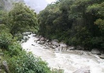
Machu Picchu is located 7,875 feet above the sea level, in Peru, on a cloud-covered mountain ridge high above the Urubamba Valley, rendering a spectacular view of the mighty Urubamba River twisting and coiling around the base in a serpentine fashion. Read our guide for more facts and information…
Machu Picchu and Huayana Picchu are situated on a loop of the Urubamba River, perched above its valley in a saddle between two peaks. The former is referred to as the ‘Old Peak’ and the latter is referred to as the ‘New Peak.’ Identified as an important site of the ancient Inca ruins, Machu Picchu is found to be almost intact since its construction in the 1400s. It is remarkable to note that it has escaped detection by the Spanish Conquistadors because history reveals that they were close enough to the site to spread a small pox epidemic that wiped out the inhabitants of the city.
Course of the Urubamba River
The Urubamba River, called Río Urubamba in Spanish, is a headwater of the Amazon River, rising in the Andes at southern Peru, and flows for nearly 450 miles to join the Apurímac to form the Ucayali. Urubamba’s upper part flows towards the south-east of Cuzco to form the Vilcanota River, and runs past Sicuani, Urcos and Urubamba towns. This part is occupied by Indian farmers. At the Gorge of Torontoy, it falls from a height of 11,000 feet to 8,000 feet through a distance of twenty miles. The Cuzco-AguasCalientes railroad is parallel to the river in this region, allowing visitors heading to Machu Picchu to get stunning views of the River. The lower part of the River from Quillabamba is occupied by a thin population.
Divisions of the Urubamba River
The Upper Urubamba and Lower Urubamba are the major divisions of the river. The Pongo de Mainique, a whitewater canyon, forms the division. The former, called Alto Urubamba, is highly populated and forms an important source of irrigation. It contains much of the Inca Empire ruins including the mystical city of Machu Picchu. The latter, called Bajo Urubamba, is not as thickly populated, but is occupied by indigenous tribes, such as Campa tribes. The Sepahua town is a notable settlement in this region and forestry forms the main occupation in this area.
Machu Picchu and the Urubamba River
Machu Picchu sits atop a high ridge, which drops off to the Urubamba River on either side. The river curves around the mountain which seats the Machu Picchu sanctuary. Its ruins and a few green terraces associated with it are visible from the river below. Though it is not navigable near Machu Picchu, down the river, it is possible to travel by boat to the Amazon River. The portion of the river between Pisac and Ollantaytambo, i.e., the Wilcamayu, is well-known as the Sacred Valley. It is said that the base perimeter of the Machu Picchu ruins are hydro-energized on three sides by the Urubamba River’s pounding rapids.
With interlocking rocks and terraced land, the beauty and mystery of Machu Picchu are appealing to pilgrims and tourists alike. The enigma associated with this place is thought-provoking though a journey to this place is highly enlightening, as put forth by those who have been fortunate to tread this place.


