Landreforms
Around 140 million years ago-the land mass of Antarctica was joined to Australia, India, Africa and South America, making up the supercontinent of Gondwana, in which offshore New Zealand was a part of the continental shelf.
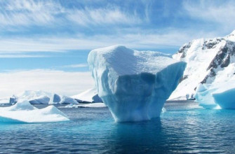
It contains two distinct sections-the ancient continental shield of East Antarctica and the more recent rock of West Antarctica, divided by the Transantarctic Mountains. Much of this land is buried beneath about 30 million cubic km (18,630,000 cubic miles) of ice-in some places greater than 4500 m (14,765 feet) thick and lacks any life larger than bacteria or algae.
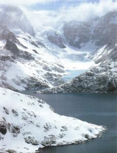
In East Antarctica the ice is so heavy that it has depressed the land by about 1000 m (3280 feet) so that in places where the ice has melted uplift occurs. This can be seen in the Australian sector most spectacularly at the Vesrfold Hills at Davis Station where arms of the sea had become trapped by uplift to form lakes that, depending on the amount of inflow, extend from freshwater to salinity up to nine times that of seawater.
One of these, Deep Lake, it so salty it remains liquid even in midwinter. Most of the Antarctic coastline consists of icecliffs or glaciers and includes the 200 km (125 mile) wide Amery Ice Shelf, the seaward extension of the Lambert Glacier.
This glacier, at 400 km (250 miles) long and more than 40 km (25 miles) wide and draining one million sq. km (385,000 sq. miles), is the largest in the world. Generally, the ice slopes back from the sea to the height of the Antarctic plateau at 4100 m (13,450 feet).
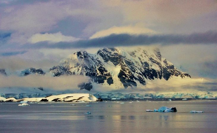
Antarctica is the highest continent on Earth, and averages 2300 m (7550 feet), way over Australia’s average of 340 m (1115 feet) to get the idea. The highest exposed land in Antarctica is outside the Australian sector at Vinson Massif (5140 mt).
Subantarctic Heard Island lies on the world’s largest marine plateau. An active volcano, its glaciers extend from its highest point, Mawson Peak, to sea level so that an amazing 80 percent of the land is ice-covered.
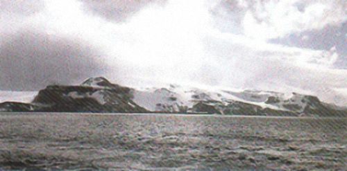
Its summit, Mawson Peak, is the highest point in Australian territory at 2745 m (9000 feet)
Further to the east lies Macquarie Island, which rises to 425 m (1400 feet). It is oceanic in origin, part of a system of trenches and ridges called the Macquarie Ridge Complex. This island arose with the uplifting of a block of ocean-floor material that was subsequently reshaped by erosion, sea level changes and periglacial action. The degree of glaciation on the island in the past, if any, is still being debated bur there are no present-day glaciers on the island.
Weather and climate
As well as being the highest continent, Antarctica is also the driest (although it contains 90 per cent of the world’s fresh water, the snow accumulation on the plateau is only about 50 mm (2 inches) water equivalent per year), coldest (the lowest temperature recorded in the Australian Antarctic Territory at Vosrok is also a world record at -89.6°C (-129°F) and windiest (at Commonwealth Bay in 1912-13 Mawson recorded winds averaging greater than 65 km ( 40 miles) per hour for over 60 per cent of the time).
Antarctica is not just subject to the weather, it dominates it, helping to generate the circling low pressure systems that bring westerly winds and precipitation to both the Subantarcric islands and the southern Australian mainland and finally dissipate at about 60°S. On the coast the temperatures average -15°C to -30°C (5°F to -22°F) in winter and about freezing point in summer. Temperatures inland in the winter months may average as low as -70°C (-94°F).
Where the cold Antarctic waters meet the waters subtropical waters at an area known as the Antarctic Convergence, the water temperature drops from 4°C to 2°C (39°F to 36°F) in just 250 km (155 miles).
The Convergence passes to the north of Heard Island but to the south of Macquarie Island so that Heard Island has snow to sea level for three months of the year whereas the snow falling in Macquarie Island is ephemeral. Average temperatures on 1 and Island at sea level in the coolest and warmest month are -1.5°C and 3.5°C (29°F and 38°F), whereas on Macquarie Island they are 3.5°C (38°F) in the coolest month to 7°C (45°F) in the summer.
Flora
Although the combination of cold and dryness in Antarctica is generally inimical to life, lichens, which are able to function at low temperatures with low light and water levels, can be found on rocks within 400 km (250 miles) of the South Pole and in the Vesrfold Hills, where high salinity is added to cold and dryness, algae may even grow under pieces of quartz where sufficient sunlight for photosynthesis is transmitted through the rock.
The most common plants that occur in Antarctica are mosses and lichens but there is a species of grass (Deschampsia antarctica) and a pearlwort (Colobantbus quitensis) that are found in the Antarctic Peninsula region.
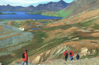
By contrast, both Heard and Macquarie Islands are comparatively blooming. Although both islands arc approximately the same size, Heard Island has less area available for plant growth as only 20 per cent of the land surface is free from glaciers and it is subject to a harsher environment. There are about 42 species of moss, 40-50 lichens, about 20 liverworts and 11 species of vascular plants (mostly grasses).
As well, there is Acaena with its well-known barbed seeds, a species of buttercup (Ranunculus crassipes), Kerguelen cabbage (Pringlea anticorbutica, which is a member of the same family as domestic cabbage), used in the past as a remedy against scurvy by scalers, while a major colonising species found inland is Azorella, a species of cushion plant. Plants thrive more readily on Macquarie Island, which has 45 native vascular planes and another three species that have been introduced by humans.