
Are you going on holiday to Italy? Do want to know a little about the geography of Italy? Our guide to Italy’s geography gives you the facts & information you’ll want to know.
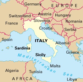
The distinct shape of Italy makes it one of the easiest countries in the world to identify on a geographical map. Mainland Italy is shaped like a boot kicking the Italian islands of Sicily and Sardinia westwards. The geographical formation that Italy comprises is known as a peninsula, which means it is surrounded on three sides by water. Italy lies in the centre of the Mediterranean Sea and has land borders with France, Switzerland, Austria and Slovenia. Italy has territorial water borders with several Balkan states including Croatia, Serbia, Albania and Greece. Italy has dozens of small Islands scattered around its shoreline; however, the two main Islands in Italy with significant populations are Sicily and Sardinia.
Coastal Geography of Italy
Italy has an interesting coastal geography with a total of 8000km of shoreline. The Italian coast looks onto four different seas. The Adriatic Sea lies off the eastern coast of Italy and on the other side of the Sea is Croatia. The Ionian Sea is slightly further south and lies between the south east coast of Italy and Greece. The Tyrrhenian Sea lies between the west coast of Mainland Italy and the Italian Island of Sardinia and Corsica which belongs to France. Finally the Ligurian Sea is the body of Water that lies off the North West coast of Italy and the border with France. The actual coastal geography of Italy varies greatly depending on which part of the country you are in. On the Amalfi coast in the Campania region of Italy, much of the shoreline is composed of cliffs, while the Island of Sardinia in Italy is famous for its golden sandy beaches.
Mountain Geography of Italy
The geography of Italy is extremely mountainous. Approximately three quarters of the land area of mainland Italy is composed of mountains. Italy has two main mountain ranges. The Bigger of the two mountain ranges in Italy is the Apennine mountain range which runs vertically from the North West of Italy near Genoa, to the South of Italy near Calabria. The total length of the Apennine mountain range in Italy is about 1500km and Divides the east coast of Italy from the west coast. The other mountain range in Italy is smaller although more famous. The Italian Alps run across the length of the north of Italy and are shared with France, Switzerland and Austria. It is in the Alps where most people in Italy go skiing. The highest peaks in the Italian Alps are almost 5000 metres above sea level and Italy is home to at least part of the world famous Matterhorn Mountain.
Positional Geography of Italy
The capital city of Italy is Rome, which is situated at a latitude of 41:54 North and a longitude of 12:27 East. The positional geography of Italy does not vary a great deal in terms of longitude; however, its long and stretched shape from the north of Italy to the south means that there are significant differences in terms of latitude.