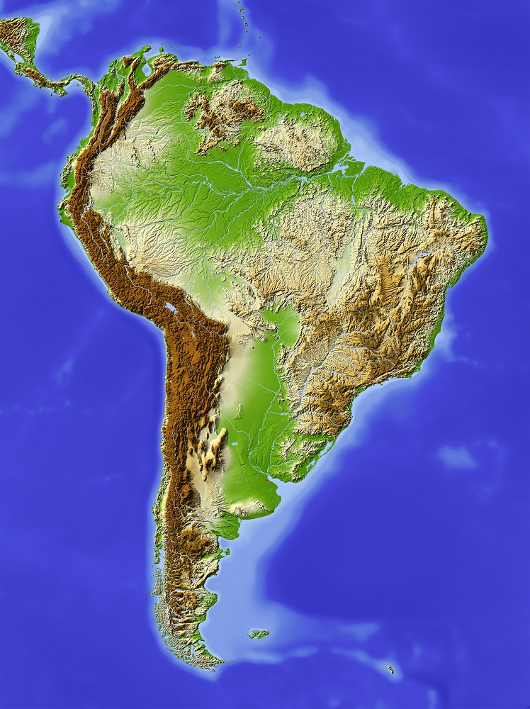
Brazil covers 8.5 million square kilometers, making it the fifth-largest country on Earth and the largest in South America. It shares borders with every South American nation except Chile and Ecuador. That territory holds five distinct physiographic regions – the Amazon lowlands, the Brazilian Highlands, the Guiana Highlands, the Pantanal wetland, and a 7,500-kilometer Atlantic coastline – each with its own elevation profile, drainage system, and ecological character. The GSC query “physical features of Brazil” pulls searchers toward exactly this breakdown, so this article maps the country’s terrain from the river basins to the mountain ridges.
Five Physical Regions That Define Brazil’s Terrain
Geographers divide Brazil into five main physiographic zones. Each zone differs in altitude, soil composition, vegetation cover, and water systems. The Amazon lowlands dominate the north. The Brazilian Highlands spread across the center and south. The Guiana Highlands rise along the northern border with Venezuela. The Pantanal fills a depression in the west. The Atlantic coastal strip runs the full eastern edge of the country.
- Amazon Lowlands – flat river basin averaging 100-200 meters above sea level, covers roughly 60% of Brazil’s territory
- Brazilian Highlands (Planalto Brasileiro) – plateau system spanning eight states, elevations from 300 to 2,800 meters
- Guiana Highlands – ancient shield rock formation along the northern border, home to Brazil’s highest peak
- Pantanal – the world’s largest tropical wetland at roughly 170,000 square kilometers
- Atlantic Coastal Lowlands – narrow strip between the ocean and the Serra do Mar escarpment, 7,500 km long
The Amazon Basin and Its River Network
The Amazon Basin occupies more than half of Brazil’s total area. The Amazon River itself stretches over 6,400 kilometers from its source in the Peruvian Andes to its mouth near Belem, where it discharges roughly 20% of all river water entering the world’s oceans. During the wet season, the river expands to nearly 50 kilometers at its widest point. Around 1,100 tributaries feed into the main channel, including the Rio Negro, the Madeira, and the Tapajos.
The basin floor sits at low elevation – rarely above 200 meters – and the terrain is almost entirely flat. Seasonal flooding transforms the landscape: water levels rise by 9 to 12 meters between December and June, submerging vast stretches of forest known as varzea (white-water floodplain) and igapo (black-water floodplain). These flooded forests support fish species that feed on fruits and seeds dropped from trees above the waterline.
The Amazon rainforest within this basin contains roughly 30% of the world’s remaining tropical forest. Brazil’s equatorial climate keeps temperatures between 25 and 28 degrees Celsius year-round in the basin, with annual rainfall exceeding 2,000 millimeters across most of the region.
The Brazilian Highlands and the Great Escarpment
The Brazilian Highlands, called Planalto Brasileiro in Portuguese, form the country’s largest physiographic unit. This plateau system stretches from the state of Minas Gerais in the southeast through Goias and Mato Grosso in the center, covering eight states and averaging 500 meters in altitude. The capital city Brasilia sits on this plateau at 1,172 meters above sea level.
Three sub-regions make up the highlands. The Atlantic Plateau runs along the eastern coast and includes the Serra do Mar and Serra da Mantiqueira mountain ranges. The Southern Plateau covers the south-central states and holds fertile volcanic soil known as terra roxa (purple earth), prized for coffee and soybean cultivation. The Central Plateau extends through the interior and contains the Cerrado, a woodland-savanna biome covering 21% of Brazil’s land area.
The eastern edge of the highlands drops sharply toward the Atlantic Ocean, creating what geologists call the Great Escarpment. The Serra do Mar runs parallel to the coast for over 1,500 kilometers from Rio de Janeiro to Santa Catarina, rising from sea level to above 1,000 meters within just a few kilometers of the shoreline. This wall of rock intercepts moisture-laden Atlantic trade winds, forcing them upward and producing heavy rainfall on the windward slopes – one reason why the Atlantic Forest biome along this coast is so dense.
Mountain Ranges and Brazil’s Highest Peaks
Brazil lacks the dramatic volcanic peaks found along South America’s western edge in the Andes. Its mountains are older, more eroded formations. Pico da Neblina, the country’s highest point at 2,995 meters, sits in the Serra do Imeri along the Venezuelan border. The peak is usually shrouded in clouds – its name translates to “Peak of the Mists” – and was only confirmed as Brazil’s highest summit in 1965.
The Serra da Mantiqueira, running through Minas Gerais, Sao Paulo, and Rio de Janeiro states, holds several peaks above 2,500 meters, including Pico das Agulhas Negras at 2,791 meters. This range separates the Paraiba do Sul river valley from the interior plateau.
Key mountain ranges and their characteristics:
- Serra do Mar – 1,500 km along the coast, peaks to 2,245 meters at Pico da Caledonia, creates the Great Escarpment
- Serra da Mantiqueira – interior range in the southeast, peaks above 2,700 meters, separates river valleys
- Serra do Imeri – northern border range, contains Pico da Neblina at 2,995 meters
- Serra do Espinhaco – runs 1,100 km through Minas Gerais and Bahia, divides the Sao Francisco basin from Atlantic-draining rivers
Major River Systems Beyond the Amazon
The Parana River, at 3,942 kilometers, ranks as Brazil’s second-longest river and South America’s second-longest after the Amazon. It flows south from the Brazilian Highlands through Paraguay and Argentina before reaching the Rio de la Plata estuary. The Itaipu Dam on the Parana, shared between Brazil and Paraguay, generates over 100 terawatt-hours of electricity per year, ranking among the world’s largest hydroelectric facilities. Iguazu Falls sits on a Parana tributary near the Argentine border – 275 individual cascades spread across 2.7 kilometers of width, with the tallest drop reaching 82 meters.
The Sao Francisco River runs entirely within Brazilian territory for 2,914 kilometers, from its source in Minas Gerais through the semi-arid northeast to the Atlantic between Alagoas and Sergipe. Brazilians call it Velho Chico (Old Chico), and it serves as the primary water source for agriculture and hydroelectric power in a region that receives less than 800 millimeters of rainfall per year. The river’s importance to northeastern communities extends beyond economics into cultural identity.
The Pantanal: The World’s Largest Tropical Wetland
The Pantanal stretches across 170,000 square kilometers of western Brazil, with smaller sections extending into Bolivia and Paraguay. UNESCO designated part of it as a World Heritage Site in 2000. The wetland sits in a shallow depression fed by the Paraguay River and its tributaries, at an average elevation of just 80 to 150 meters above sea level.
Seasonal flooding defines the Pantanal’s rhythm. Over 80% of the floodplain goes underwater during the rainy season from November to March. The dry season from April to September concentrates wildlife around shrinking water sources, making it one of the best places on Earth for viewing large animals in the wild. The area supports roughly 3,500 plant species, 656 bird species, 325 fish species, and 159 mammal species, including jaguars, giant otters, and hyacinth macaws.
The Cerrado savanna borders the Pantanal to the east and covers a vast area of central Brazil. The Cerrado alone holds over 10,000 plant species, of which roughly 45% grow nowhere else on Earth. Headwater streams draining through the Cerrado feed directly into the Pantanal’s seasonal flood cycle, linking the two biomes hydrologically. Together, they create a gradient from dry grassland to seasonal wetland that supports extraordinary ecological and cultural diversity across the interior states.
The Atlantic Forest biome along the southeastern coast represents another critical landscape. Once covering 1.3 million square kilometers, it has been reduced to roughly 12% of its original extent by agriculture and urban development. What remains holds around 20,000 plant species and over 2,000 vertebrate species, concentrated in fragments along the Serra do Mar and Serra da Mantiqueira slopes. Conservation efforts focus on connecting these fragments through biological corridors.
Frequently Asked Questions
What are the main physical features of Brazil?
Brazil’s five main physical features are the Amazon lowlands, the Brazilian Highlands plateau, the Guiana Highlands in the north, the Pantanal wetland in the west, and the Atlantic coastal strip. The Amazon River, the Parana River, and the Sao Francisco River form the three largest drainage systems.
What is the highest point in Brazil?
Pico da Neblina at 2,995 meters above sea level is Brazil’s highest peak. It sits in the Serra do Imeri on the Venezuelan border in Amazonas state. The peak was only confirmed as the country’s highest point in 1965.
How large is the Amazon Basin compared to Brazil?
The Amazon Basin covers more than half of Brazil’s territory. The Amazon River itself stretches over 6,400 kilometers and discharges roughly 20% of all river water that enters the world’s oceans. Around 1,100 tributaries feed into its main channel.
What makes the Pantanal different from other wetlands?
The Pantanal is the world’s largest tropical wetland at approximately 170,000 square kilometers. Over 80% of its floodplains submerge during the rainy season. It supports 656 bird species and 159 mammal species, giving it a higher species count than any other wetland ecosystem.
Sources and Further Reading
- LAC Geo – The Brazilian Highlands: Planalto Brasileiro (lacgeo.com)
- UNESCO World Heritage Centre – Pantanal Conservation Area (whc.unesco.org)
- Aventura do Brasil – Brazil’s Largest and Most Important Rivers (aventuradobrasil.com)
- WWF – Pantanal, South America: Facts and Conservation (wwf.panda.org)