Italy occupies 301,340 square kilometres of southern Europe, arranged around a 1,200-kilometre peninsula shaped like a boot that extends southward into the Mediterranean Sea. The country straddles the Alps in the north and reaches the Strait of Sicily in the south, with two major Mediterranean islands (Sicily and Sardinia) plus dozens of smaller islands completing the national territory. Italy’s geography has shaped everything from its regional cuisines to its political history: the Apennine mountain spine that divides the peninsula lengthwise, the Po valley plain in the north that produced the country’s industrial heartland, and the Alpine passes that connected Italy to the rest of Europe for three millennia. Roughly 59 million people live inside this territory, distributed unevenly with higher densities in the northern plains and coastal valleys and lower densities across the mountainous interior.
This guide covers Italy’s location and borders, the distinctive boot-shaped peninsula and its coastline, the two main mountain ranges (Alps and Apennines), the Po valley and other major plains, the two large islands and minor archipelagos, rivers and lakes, volcanic zones including Etna and Vesuvius, the 20 administrative regions and their geographic character, climate zones from Alpine to Mediterranean, and Italy’s position in European and Mediterranean geopolitics.
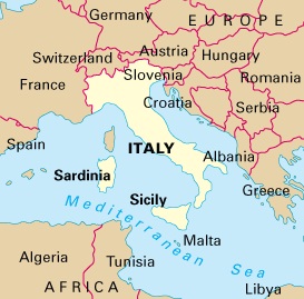
Location and Borders
Italy sits in southern Europe between latitudes 35 and 47 degrees north and longitudes 6 and 19 degrees east. The country shares land borders with four neighbours: France to the northwest (488 kilometres), Switzerland to the north (698 kilometres), Austria to the northeast (430 kilometres), and Slovenia to the east (232 kilometres). Two microstates sit inside Italian territory: San Marino (61 square kilometres, independent since 301 CE according to tradition) and the Vatican City (0.49 square kilometres, the world’s smallest sovereign state).
Italy’s coastline runs 7,600 kilometres along four major seas: the Adriatic Sea on the east facing Croatia, Slovenia, Albania, and Greece; the Ionian Sea on the southeast between Italy and Greece; the Tyrrhenian Sea on the west between the peninsula and the islands of Sardinia and Corsica (Corsica belongs to France); and the Ligurian Sea on the northwest bordering the French Riviera. The Gulf of Venice, Gulf of Taranto, Gulf of Naples, and Gulf of Genoa form the country’s most recognised coastal features.
The Mediterranean position put Italy at the centre of classical world geography. The Roman Empire used the peninsula as the organising centre for territory that stretched from Britain to the Middle East, and the subsequent history of Italy as a set of competing city-states reflected both the advantages of maritime access and the difficulty of unifying a mountainous peninsula. Modern Italy only became a unified state in 1861, with Rome added in 1870.
The Peninsular Shape
Mainland Italy’s boot shape stretches 1,200 kilometres from the northwestern Alpine borders to the tip of Calabria at the southern end, with the eastern width ranging from roughly 250 kilometres in the north to under 150 kilometres across the narrowest parts of the peninsula. The Gulf of Taranto forms the “arch” of the boot on the southeast, separating the heel (Puglia region) from the toe (Calabria region).
The Strait of Messina, only 3.1 kilometres wide at its narrowest point, separates mainland Calabria from Sicily. A long-running plan to bridge the strait has surfaced and stalled in Italian politics since the 1970s; an actual Messina Bridge project finally resumed construction work in the 2020s with completion targeted later in the current decade.
This peninsular geography produces practical results: no Italian city sits more than 250 kilometres from the sea, and most are much closer. Even Milan, the farthest major city from the coast, lies 170 kilometres inland. The maritime orientation has shaped Italian cuisine (seafood accessible everywhere), history (naval republics of Venice, Genoa, Amalfi, Pisa), and modern tourism (Italian beaches receive more visitors than almost any other European country’s).
The Alps: Italy’s Northern Mountains
The Alps arc across Italy’s northern border for roughly 750 kilometres, with the country’s portion known as the Italian Alps. These are among the highest mountains in Europe, with many peaks over 4,000 metres. The major subranges running west to east:
- Maritime Alps and Ligurian Alps: form the French-Italian border, drop toward the Ligurian Sea
- Cottian Alps: include Monte Viso (3,841 metres)
- Graian Alps: hold Gran Paradiso (4,061 metres, Italy’s highest peak wholly within the country) and part of Mont Blanc (4,810 metres, shared with France)
- Pennine Alps: include Monte Rosa (4,634 metres) and the southern side of the Matterhorn (4,478 metres, shared with Switzerland)
- Lepontine Alps: centred around the Swiss-Italian border
- Rhaetian Alps: dominated by the Bernina massif (4,049 metres, Piz Bernina shared with Switzerland)
- Dolomites: a limestone subrange distinct from the main Alpine spine, with peaks like Marmolada (3,343 metres) and the Tre Cime di Lavaredo, UNESCO World Heritage Site since 2009
- Carnic Alps and Julian Alps: run east along the Austrian and Slovenian borders
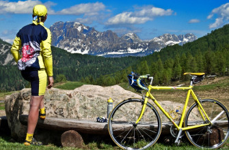
The Alpine valleys hold distinct cultural identities. Valle d’Aosta retains French as a co-official language; Alto Adige (South Tyrol) speaks German alongside Italian; Friuli-Venezia Giulia includes Slovenian-speaking villages. The Alps also shape Italian skiing: Cervinia, Courmayeur, Madonna di Campiglio, Cortina d’Ampezzo, and Sestriere rank among Europe’s major resort destinations.
The Apennines: Italy’s Spine
The Apennine mountains run 1,350 kilometres from northwest of Genoa to the southernmost tip of Calabria, dividing the eastern and western sides of the peninsula. The range is generally lower than the Alps but still reaches 2,912 metres at Corno Grande in the Gran Sasso massif. The Apennines form subranges across their length:
- Ligurian Apennines: short range near the Ligurian coast
- Tuscan-Emilian Apennines: divide Tuscany from Emilia-Romagna
- Umbrian-Marchigian Apennines: through Umbria and Marche
- Central Apennines: the highest subrange, with Gran Sasso and Majella massifs
- Neapolitan Apennines: including the volcanic area around Naples
- Lucanian Apennines: through Basilicata
- Calabrian Apennines (Sila and Aspromonte): the southern subranges
The Apennines divide Italy’s climate and culture. The Adriatic side tends cooler and drier; the Tyrrhenian side warmer and more Mediterranean. The mountain spine also limited east-west communication historically, which contributed to the development of distinct regional identities that persist today. Traditional pasta shapes, wines, dialects, and cuisine still vary sharply across a 100-kilometre distance when a 2,000-metre mountain ridge sits between two regions.
The Po Valley and Other Plains
The Po Valley (Pianura Padana) stretches 650 kilometres across northern Italy between the Alps and the Apennines, covering 46,000 square kilometres. This is by far Italy’s largest plain and holds 30 percent of the national population, including Milan, Turin, Bologna, Venice, Verona, Parma, and Modena. The plain formed from sediments deposited by the Po river and its tributaries over geological time.
The Po Valley drives the Italian economy. Lombardy alone produces over 20 percent of national GDP. Agriculture is intensive: rice paddies in the western Po plain produce most European risotto rice; Parmigiano Reggiano, Prosciutto di Parma, and Aceto Balsamico di Modena come from specific Po Valley subregions.
Other significant Italian plains:
- Plain of Campania (around Naples): fertile volcanic soils, high agricultural productivity, Italy’s most densely populated region
- Tavoliere delle Puglie: second-largest Italian plain (3,000 square kilometres), breadbasket of southern Italy
- Maremma: coastal plain in southern Tuscany and northern Lazio, historically malarial and sparsely populated
- Agro Pontino: marshland south of Rome drained under Mussolini in the 1930s, now agricultural
- Piana di Catania: the largest plain on Sicily, around Catania at the foot of Mount Etna
Sicily and Sardinia
Italy’s two largest islands together hold 7.5 million residents and cover nearly 50,000 square kilometres of Italian territory.
Sicily (Sicilia) is the largest Mediterranean island at 25,711 square kilometres and the largest administrative region of Italy with 5 million residents. The island holds Mount Etna, Europe’s tallest active volcano at 3,357 metres. Sicily’s position between Africa and Europe produced a layered history: Greek colonies from the 8th century BCE, Carthaginian control, Roman province, Byzantine, Arab emirate (831-1091), Norman kingdom, and the long union with Southern Italy under successive dynasties. Palermo, the regional capital, displays this layering in its architecture. Other major Sicilian cities include Catania, Messina, Syracuse (Siracusa), and Taormina.
Sardinia (Sardegna) is the second-largest Mediterranean island at 24,100 square kilometres with 1.6 million residents. The island developed differently from Sicily: less Greek influence, longer Byzantine and independent medieval period, and Spanish rule from the 14th century to 1720. The Sardinian language (called Sardu) is linguistically distinct enough from Italian that most linguists classify it as a separate Romance language rather than a dialect. The interior Barbagia region retains traditional pastoral culture; the Costa Smeralda on the northeast coast became a tourist destination from the 1960s.
Rivers and Lakes
Italy’s major rivers run either east to the Adriatic or west to the Tyrrhenian, following the drainage split created by the Apennines. The most significant:
- Po: 652 kilometres, longest river in Italy, drains the northern plain to the Adriatic
- Adige: 410 kilometres, second-longest, flowing from the Alps through Verona to the Adriatic
- Tiber (Tevere): 405 kilometres, flows through Rome to the Tyrrhenian Sea
- Arno: 240 kilometres, flows through Florence and Pisa to the Ligurian Sea
- Piave: 220 kilometres, major river of the Veneto region
Italy’s Alpine lakes form a distinctive band at the southern edge of the Alps:
- Lake Garda: 370 square kilometres, largest Italian lake
- Lake Maggiore: 212 square kilometres, shared with Switzerland
- Lake Como: 146 square kilometres, famous for villa architecture
- Lake Iseo, Lake Lugano, Lake Orta: smaller but scenically important
Volcanic lakes in central Italy include Lake Trasimeno (Umbria), Lake Bracciano and Lake Bolsena (Lazio). Sicily has smaller lakes at the foot of Mount Etna.
Volcanic Italy
Italy is one of the more geologically active European countries, sitting on the boundary between the African and Eurasian tectonic plates. Four major volcanic systems define the Italian landscape:
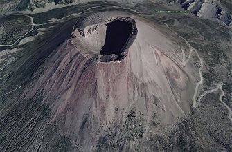
- Etna (Sicily): 3,357 metres, Europe’s tallest active volcano, continuously erupting in mild form. UNESCO World Heritage Site since 2013. Recent major eruptions affected surrounding villages repeatedly.
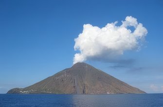
- Stromboli (Aeolian Islands): 924 metres, in near-continuous strombolian eruption for at least 2,000 years, lighting the night sky
- Vesuvius (Campania): 1,281 metres, famous for the 79 CE eruption that destroyed Pompeii and Herculaneum. Currently dormant but expected to erupt again within human timescales.
- Vulcano (Aeolian Islands): the island that gave its name to all volcanoes in European languages. Last erupted 1888-1890.
- Campi Flegrei (Phlegraean Fields): a large caldera west of Naples, showing recent ground-level changes indicating potential future activity
- Ischia, Pantelleria, and Aeolian Island minor cones: smaller volcanic features
Earthquakes also affect Italy regularly. The 2009 L’Aquila earthquake, 2012 Emilia earthquake, 2016 Amatrice-Accumoli-Norcia earthquake sequence, and 2017 Ischia earthquake all caused significant damage and loss of life. Seismically active zones run along the Apennine spine and in Sicily.
The 20 Regions and Their Geography
Italy’s administrative geography divides the country into 20 regions, each with distinct geographic character:
- Northwestern Alpine: Valle d’Aosta, Piedmont, Liguria
- Northern Plains and Lakes: Lombardy, Veneto, Trentino-Alto Adige, Friuli-Venezia Giulia, Emilia-Romagna
- Central Tyrrhenian: Tuscany, Lazio, Umbria, Marche
- Central Adriatic and Apennine: Abruzzo, Molise
- Southern Mainland: Campania, Puglia, Basilicata, Calabria
- Islands: Sicily, Sardinia
Five regions hold special autonomous status (Valle d’Aosta, Trentino-Alto Adige, Friuli-Venezia Giulia, Sicily, Sardinia), reflecting linguistic minorities, island status, or post-war political arrangements. Each region holds its own council and president with significant devolved powers over health, education, and regional planning. For context on Italian administration, see our Italian school holidays guide which covers how regional autonomy affects school calendars.
Climate Zones
Italy spans four major climate zones due to its north-south length and mountain topography:
- Alpine climate: Alpine regions above 1,000 metres, cold winters with heavy snow, cool summers. Winters can fall to -20 Celsius in high valleys.
- Humid subtropical / continental: Po Valley and northern inland areas, hot humid summers (30-35 degrees) and cold winters (sometimes below zero), fog common in winter
- Mediterranean: coastal areas from Liguria to Sicily, hot dry summers (25-33 degrees) and mild winters (5-12 degrees), low rainfall concentrated in autumn and spring
- Apennine mountainous: inland central Italy, moderate summers and cold winters with heavier rainfall than adjacent plains
These zones produce Italy’s range of agricultural products: citrus from Sicily and southern Calabria, olive oil across central and southern Italy, wine from every region, rice and dairy from the Po Valley, Alpine cheeses and wine from the Alpine valleys.
Italy’s Position in European Geography
Italy functions as a natural bridge between continental Europe and the Mediterranean world. The Alpine passes (Brenner, St Gotthard, Simplon, Mont Cenis, Little St Bernard) connected Italian Renaissance trade routes to central Europe; the southern ports (Brindisi, Bari, Naples, Palermo) linked to Greece, Egypt, and the Levant. Modern EU integration and high-speed rail have made these historic connections much denser: Milan connects to Paris in 7 hours and to Frankfurt in 8 hours by rail; Rome connects to Naples in 70 minutes on the high-speed line.
Italy’s NATO and EU membership (founding member of both, and of the earlier European Coal and Steel Community) reflects the country’s strategic position on the southern European frontier. The Mediterranean coast faces North Africa (Tunisia is 150 kilometres from the Sicilian coast at the Strait of Sicily narrows), which has made Italy a major arrival point for migration flows from sub-Saharan Africa across the Mediterranean routes since the 2010s.
For historical context on Italy’s role in ancient Mediterranean geography, see our history of Rome guide.
Frequently Asked Questions
What is the geography of Italy?
Italy covers 301,340 square kilometres of southern Europe as a boot-shaped peninsula plus two main islands (Sicily and Sardinia). The country has 7,600 kilometres of coastline along four seas, two major mountain ranges (Alps in the north, Apennines running lengthwise), the Po Valley as its largest plain, and active volcanoes including Etna, Vesuvius, and Stromboli.
What shape is Italy?
Mainland Italy is shaped like a boot extending southward into the Mediterranean Sea. The Gulf of Taranto forms the arch of the boot; Puglia is the heel; Calabria is the toe. Sicily sits just across the Strait of Messina from the toe, and Sardinia sits 200 kilometres west of the mainland.
What countries border Italy?
Italy shares land borders with four countries: France (northwest), Switzerland (north), Austria (northeast), and Slovenia (east). Two microstates sit inside Italian territory: San Marino and Vatican City.
What are the main mountains in Italy?
Two major ranges: the Alps along the northern border (shared with France, Switzerland, Austria, and Slovenia; holding peaks above 4,000 metres) and the Apennines running down the peninsula from Liguria to Calabria (reaching 2,912 metres at Corno Grande). The Dolomites form a distinct limestone subrange of the eastern Alps.
What is the longest river in Italy?
The Po, at 652 kilometres, is Italy’s longest river. It flows west to east across the northern plain from the Cottian Alps to the Adriatic Sea, passing Turin, draining 74,000 square kilometres of northern Italy in the process.
How many regions does Italy have?
Italy has 20 administrative regions, 5 of which hold special autonomous status (Valle d’Aosta, Trentino-Alto Adige, Friuli-Venezia Giulia, Sicily, Sardinia). Each region operates its own council and has significant devolved powers over health, education, and regional planning.
Which seas surround Italy?
Four seas: the Adriatic on the east (facing Croatia, Slovenia, Albania, and Greece), the Ionian on the southeast (between Italy and Greece), the Tyrrhenian on the west (between mainland Italy, Sardinia, and Corsica), and the Ligurian on the northwest (bordering the French Riviera).
Sources and Further Reading
- The Cambridge Companion to Modern Italian History – Christopher Duggan, Cambridge University Press
- Italy: A Reference Guide from the Renaissance to the Present – Frank J. Coppa, Facts on File
- Geology of Italy – Marco Pantaloni et al, Geological Society of Italy
- Italian Ministry for the Environment data – mase.gov.it
- ISTAT Italian geographic and demographic statistics – istat.it
- UNESCO World Heritage documentation for the Dolomites and Mount Etna – whc.unesco.org