Fuerteventura is built from volcanoes, but it is so old and so eroded that they read as soft brown cones and black lava fields rather than the sharp peaks of younger islands. That makes for some of the most accessible volcano walking in the Canaries, with short crater hikes and strange lava badlands within easy reach of the resorts. This guide covers the best walks, what to expect underfoot, and how to do them safely. For the full island picture, see our Fuerteventura travel guide.
The oldest of the Canaries
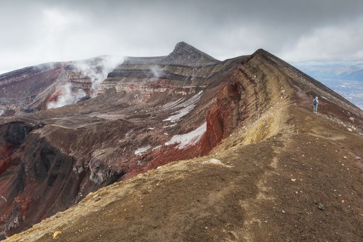
Fuerteventura is the oldest island in the archipelago, with its first volcanoes rising from the sea around 20 million years ago. Millions of years of wind and rare rain have worn the old massifs down to the low, rounded ridges that define the interior, while the most recent eruptions, only a few thousand years old in the north, left fresher cones and the dark lava badlands the islanders call malpais, meaning bad country. Walking here is a walk through that contrast: ancient eroded mountains in the centre and south, young craters and raw lava in the north.
The best volcano walks
A handful of walks stand out for their mix of accessibility and reward:
- Calderon Hondo: the classic, near Lajares in the north. An easy, well-marked and free trail of a couple of kilometres leads to the rim of a crater roughly 50,000 years old, with a viewpoint over the caldera and out to the dunes and Lobos. Barbary ground squirrels beg along the path.
- Bayuyo and the Lajares volcanoes: the chain of young cones behind Corralejo, a longer ridge walk linking several craters with wide coastal views.
- Malpais de la Arena: a protected lava field near Villaverde, where a trail crosses the badlands around a single large cone, the clearest place to see how the raw lava slowly turns to soil.
- Montana de Tindaya: the sacred mountain of the aboriginal Majoreros near La Oliva, climbed for its podomorfo rock carvings and its presence rather than its height, with access partly restricted to protect it.
- Pico de la Zarza: not a volcano walk as such but the island’s highest point at 807 metres on the Jandia peninsula, a steady climb from Morro Jable to a view over the wild Cofete coast.
What to expect underfoot
The walking here is unlike the green trails of the western Canaries:
- Loose volcanic ground: the cinder slopes and lava fields are rough and loose, so proper walking shoes with grip beat trainers.
- No shade at all: there are no trees on these routes, so sun cover, a hat and plenty of water are not optional, even on a short walk.
- Wind: the trade wind blows steadily and harder on the ridges and the high points, so a windproof layer helps.
- Easy navigation: the popular routes like Calderon Hondo are well marked, but the malpais and the longer ridge walks reward a map or a tracked route.
The Calderon Hondo walk in detail
Since it is the walk most visitors do, it helps to know what the Calderon Hondo route actually involves. The trail starts from the edge of Lajares village, where there is roadside parking, and follows a clear, gently rising track across the lava plain toward the cone. The full loop runs to roughly five kilometres there and back with modest ascent, taking most walkers about an hour and a half at an easy pace. The reward at the top is a fenced viewpoint over the crater, a near-perfect bowl dropping away beneath you, with a panorama that takes in the chain of neighbouring cones, the Corralejo dunes and the islet of Lobos. The path’s other inhabitants are the Barbary ground squirrels, introduced from North Africa decades ago, which gather at the viewpoint expecting food. They are tame and endearing but feeding them is discouraged, since it is bad for the animals and against the spirit of the protected reserve. Go early or late to dodge the midday heat and to catch the best light over the crater, and wear shoes with grip for the loose final stretch.
More volcanoes in the south and centre
The north has the famous young cones, but the centre and south hold rewarding volcanic walking that few visitors reach:
- Caldera de Gairia: a near-perfect cone near Tiscamanita, protected as a Natural Monument and rising to 461 metres, climbed by an easy linear trail of around two and a half kilometres in about an hour, with a crater at the top and a view over the surrounding lava plains and calderas.
- Malpais Grande: a vast plain of black lava near Tuineje, one of the largest badlands on the island, where trails cross old flows and you can pick out craters, cones and the collapsed tubes that once carried lava, the clearest place to read how a recent eruption reshaped the land.
- Arco de las Penitas: in the eroded central massif near the Vega de Rio Palmas, a natural rock arch reached through a green canyon and a small palm grove, the palmeral, a gentler walk that contrasts the bare volcanic ground with one of the island’s few shady corners.
Walking responsibly
The whole island is a UNESCO Biosphere Reserve, and the volcanic landscapes are fragile. The thin desert vegetation and the lava crusts recover badly from being trampled or driven over, so staying on the marked paths protects both the ground and the petroglyphs at sites like Tindaya. Some areas, including parts of Tindaya and the natural parks, have access rules that limit where you can go, so check before setting out. Taking nothing, leaving nothing and keeping to the trail is the whole of the etiquette here. The off-road tracks for vehicles are covered separately in our quad biking guide.
The geology you walk through
Part of what makes walking here rewarding is reading the ground itself, because Fuerteventura lays out volcanic history in plain sight. The eroded central massif around Betancuria exposes some of the oldest rock in the Canaries, the worn-down roots of volcanoes that have lost their cones entirely to 20 million years of weather. In the north the story is reversed and recent: the cones around Lajares and Corralejo still hold their crater shapes, and the lava that flowed from them, the malpais, has barely begun to break down into soil, which is why so little grows on it. Walk from the centre to the north and you walk forward in geological time, from ancient ground that has become farmland to raw rock only a few thousand years old. The black basalt, the red oxidised cinder, the wind-blown sand that buries old flows, and the lichens that are the first life to colonise the lava all tell part of that sequence, and a good crater walk like Calderon Hondo shows several stages at once.
Walks in the south and on the coast
The north has the famous craters, but the rest of the island rewards walkers too:
- The Jandia massif: the climb to Pico de la Zarza from Morro Jable is the island’s classic high walk, ending at 807 metres above the wild Cofete coast.
- Barranco de las Penitas: a green ravine near Betancuria with a small dam and chapel, a gentler walk through the eroded interior.
- The Vega de Rio Palmas: palm-dotted valleys in the centre that contrast with the bare volcanic ground elsewhere.
- Coastal walks near El Cotillo: level paths past the lagoons, the old lime kilns and the watchtower, easy and scenic for a slower day.
Combining a walk with the day
The volcano walks pair naturally with the rest of the north. Calderon Hondo sits minutes from Lajares and its surf cafes and from the calm lagoons of El Cotillo, so a morning crater walk and an afternoon swim is an easy combination, covered in our guides to things to do in Corralejo and the island’s best beaches. In the south, Pico de la Zarza fits with a stay in Jandia and a trip to Cofete.
Frequently asked questions
What is the best volcano walk in Fuerteventura?
Calderon Hondo near Lajares is the standout: an easy, free, well-marked trail to a 50,000-year-old crater rim with wide views, suitable for most fitness levels and families.
Are the volcanoes in Fuerteventura active?
No. The island is the oldest in the Canaries and has had no eruptions in recorded history. The youngest cones in the north are a few thousand years old, and the landscape is now dormant.
Is the Calderon Hondo hike hard?
No, it is one of the easier crater walks in the Canaries, a couple of kilometres on a marked path with modest climbing, though the loose ground and total lack of shade call for good shoes, sun cover and water.
What is malpais?
The local name, meaning bad country, for the rough lava badlands left by recent eruptions, such as the protected Malpais de la Arena near Villaverde, where trails cross the raw volcanic terrain.
Can you climb Tindaya mountain?
Access is partly restricted to protect its aboriginal podomorfo rock carvings and its status as a sacred site, so check current rules before planning a climb rather than assuming open access.
How long is the Calderon Hondo hike?
About five kilometres there and back from Lajares, with modest climbing, taking most walkers around an hour and a half. The path is clear and marked, ending at a fenced viewpoint over the crater.
Do you need a guide to walk the volcanoes?
Not for the popular, marked routes like Calderon Hondo, which are easy to follow alone. A guide or a tracked map helps on the longer ridge walks and across the malpais, where paths are fainter, and adds the geology and history along the way.