
Interested in the geography of ancient China? Want to know about the geographical knowledge possessed by ancient Chinese scholars? Read our guide for more facts & information…
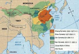
While the landforms in ancient China remain much the same as they were thousands of years ago, the people’s relationships with the land are now quite different. The geography of ancient China can be conveniently divided up into three regions: 1) The Yangtze and Yellow Rivers; 2) The Gobi and Taklamakan Deserts; and 3) The Himalayas …
Yangtze and Yellow Rivers
In ancient China, the importance of the Yangtze and Yellow Rivers is hard to overstate. People mostly settled along these rivers, and different settlements were ruled by different kings. The Yangtze is 4,000 miles long and is banked by fertile flood plains which are added to each year when the Yangtze floods. The Yangtze Harbor is home to evidence that humans inhabited the area some 27,000 years ago. During the Han Dynasty (202 BCE-220 CE) the Yangtze became more important economically and politically due to the establishment of irrigation systems.
Several times in the history of ancient China, the Yangtze was a political boundary between northern and southern China because it wasn’t an easy river to cross. The riverbanks were the sites of several battles both in ancient history and up to the Battle of Red Cliffs in 208 AD, which set up the confrontation of the three kingdoms Wei, Shu, and Wu from 220-280 CE.
To the north of the Yangtze, the Yellow River is 3,000 miles long and floods each year. Because of this, settlers in ancient China often saw their homes destroyed year after year during flood season, but eventually the people learned techniques to control flooding.
Gobi and Taklamakan Deserts
Most of the Gobi Desert is covered with rocks rather than sand. The Gobi Desert is located in the northwestern part of China and is one of the driest deserts in the world. It is also a very cold place in winter, with nighttime lows reaching -40 degrees Fahrenheit. Though the two are connected, geographers and ecologists regard the western part of the Gobi as a separate desert, the Taklamakan Desert.
The Taklamakan Desert sometimes goes by the name Sea of Death. It has poisonous snakes, sand storms, and temperature extremes. It is the second largest desert in the world and is a home to species of poisonous snakes. Because of the extreme conditions of these two deserts, they acted as another protective barrier in China’s northwest.
Himalayan Mountains
The people of ancient China were protected from invaders by the Himalayan Mountains, which contain several of the highest mountain peaks in the world. Because of its inland geography, the mountains not only experience extreme cold in the winter, but extreme heat in the summer, where temperatures can reach 100 degrees Fahrenheit (40 degrees Centigrade), making them climatologically as well as physically a barrier.
Ancient Chinese history and culture were heavily influenced by its geography. With the barriers of the deserts to the northwest, and the Himilayas to the southwest, the culture remained fairly isolated for hundreds of years. The people of ancient China relied heavily on the Yangtze River, and to some extent on the Yellow River for their livelihood.