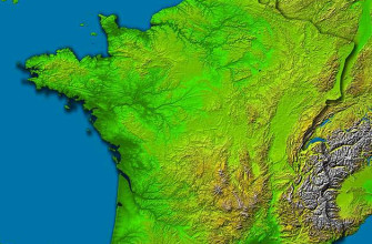
The major landforms in France are the Alps along the south-eastern border with Italy and Switzerland, the Pyrenees along the Spanish border, the Massif Central volcanic plateau in the south-central interior, the older worn uplands of Brittany, the Vosges and the Jura, the lowland Paris and Aquitaine basins, and around 5,500 kilometres of Atlantic, Channel and Mediterranean coastline. Mont Blanc rises 4,807 metres on the French-Italian frontier, the highest summit in Western Europe. This guide names the specific peaks, plateaux, rivers and shores that define the country, but it starts with the thing most landform lists skip: the two great events that built them, which is the key to why France looks the way it does.
The two events that built France
Almost every landform in France belongs to one of two mountain-building episodes separated by hundreds of millions of years, and telling them apart makes the whole map fall into place.
- The old massifs (Variscan, or Hercynian): between roughly 420 and 300 million years ago, the collision that built the supercontinent Pangaea raised a mountain belt across what is now Europe. Those mountains have since worn down to rounded plateaux and uplands, and in France they survive as the Massif Central, the Armorican Massif of Brittany, the Vosges, the Ardennes and the granite spine of Corsica.
- The young mountains (Alpine): from around 65 million years ago, Africa pushed north into Europe, crumpling the edge of the continent into the high, sharp ranges that are still rising today. This Alpine event raised the Alps, the Pyrenees and the folded Jura.
- The rift and the volcanoes: as the Alps rose, the crust to the west stretched and cracked along the Limagne rift through the Massif Central, thinning the ground enough to let magma reach the surface and build the volcanic Chaine des Puys.
- The basins between: the low ground of the Paris Basin and the Aquitaine Basin is where sediment collected in the broad sags between the old massifs and the young mountains, layer upon layer of chalk, limestone and clay.
So France is, in short, two sets of worn-down old mountains and two sets of fresh high ones, with two great sedimentary basins filling the gaps and a rift line of volcanoes down the middle. Hold that in mind and the rest of the country’s geography reads easily.
Major landforms of France at a glance
The physical geography of metropolitan France splits into a handful of major regions. In descending order of elevation:
- The French Alps: 350 kilometres of high mountains along the Italian and Swiss borders, topped by Mont Blanc at 4,807 metres
- The Pyrenees: 430 kilometres of mountain border with Spain, highest French peak Vignemale at 3,298 metres
- The Massif Central: an eroded volcanic plateau of around 85,000 square kilometres, highest point Puy de Sancy at 1,886 metres
- The Jura and Vosges: medium mountains in the east, the folded limestone Jura on the Swiss border and the rounded Vosges above Alsace
- The Armorican Massif: the low granite uplands of Brittany and western Normandy in the north-west
- The Paris and Aquitaine basins: the great lowland plains of the north and south-west
- The coastlines: around 5,500 kilometres along the Channel, the Atlantic and the Mediterranean, plus another 1,000 along Corsica
Four major rivers organise the drainage: the Loire, the Seine, the Garonne and the Rhone. For the wider country our geography of France overview sets the human and climatic context, and our guide to the mountains of France covers the ranges as walking and skiing country.
The Alpine frontier and Mont Blanc
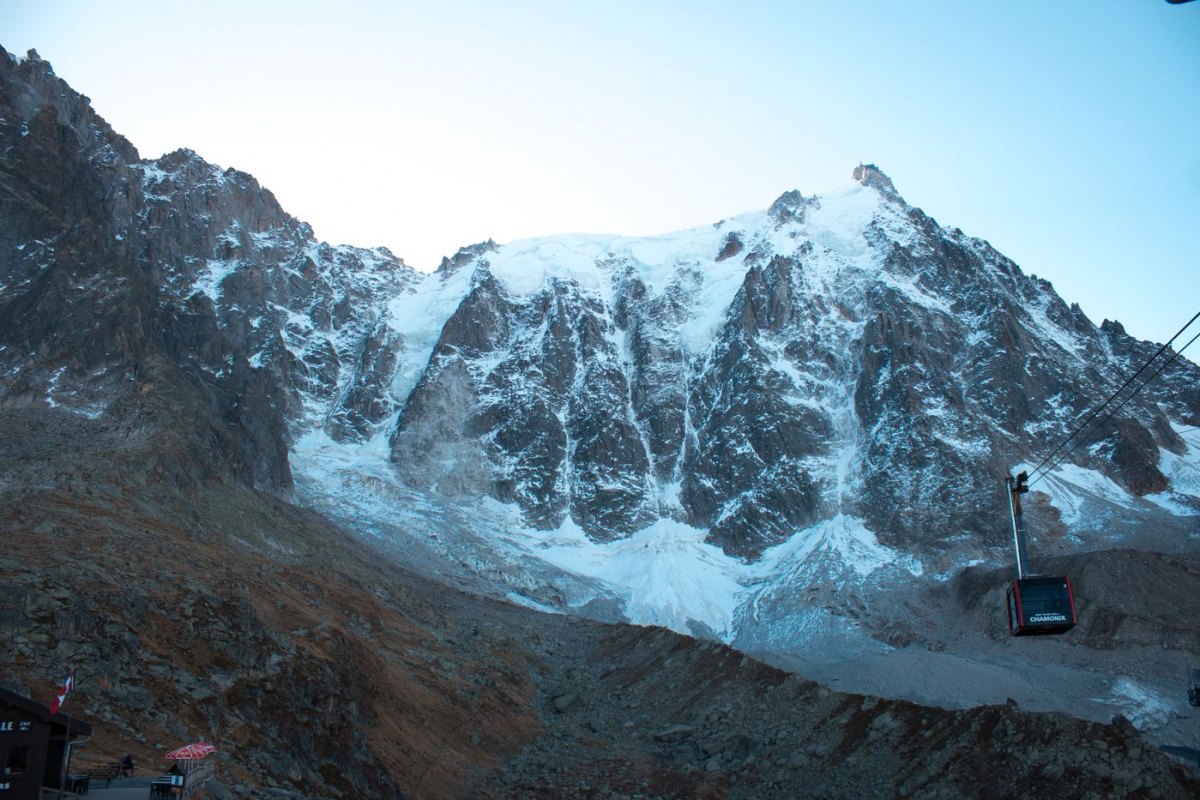
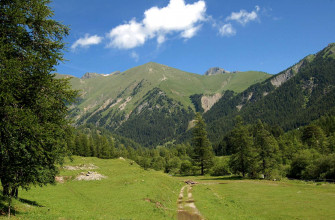
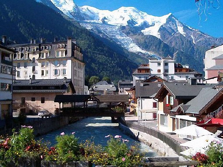
The French Alps run along the south-eastern border with Italy and Switzerland for around 350 kilometres. Mont Blanc, on the French-Italian frontier above Chamonix, is the range’s highest point and the highest in Western Europe.
The surrounding massif holds dozens of summits above 4,000 metres and the Mer de Glace, the largest glacier in France, which has retreated sharply since the mid-twentieth century and is now a visible marker of a warming climate. Further south the range broadens through the Vanoise, Ecrins, Queyras and Mercantour national parks, each protecting a different section of the high Alps.
Lower limestone pre-Alps such as the Vercors and Chartreuse sit between the high mountains and Grenoble. The Alps hold the highest land in France, and the orientation of their valleys still controls river drainage, climate exposure and where towns could grow. For the walking and touring side, see our French Alps hiking routes.
The Pyrenees along the Spanish border
The Pyrenees stretch 430 kilometres from the Atlantic at Hendaye to the Mediterranean at Banyuls-sur-Mer, forming the border with Spain and Andorra. Vignemale, the highest French peak at 3,298 metres, sits inside the Pyrenees National Park above a series of cirques carved by ice-age glaciers.
The Cirque de Gavarnie, a UNESCO World Heritage site, is the most spectacular of them, a near-vertical limestone amphitheatre around 1,500 metres deep. Down its wall drops the Gavarnie waterfall, at 422 metres the tallest in mainland France. Visitors walk in from Gavarnie village on a loop of around eight kilometres that takes most people a couple of hours, with paid parking in the village and the chance of seeing griffon vultures riding the thermals overhead.
The range divides into three: the wet, rounded Atlantic Pyrenees in the west, the high snowy Central Pyrenees with the major peaks, and the drier Mediterranean Pyrenees in the east, where the mountains drop toward the Roussillon plain. The Garonne, the Adour and other rivers rise here, and narrow passes such as the Col du Somport and Col du Pourtalet carry the crossings into Spain.
The Massif Central volcanic plateau
The Massif Central covers around 85,000 square kilometres of the south-central interior, an area larger than Austria. This is an old, eroded Variscan plateau rather than an alpine range, and its highest point, the Puy de Sancy at 1,886 metres, would barely register in the Alps.
Its character comes from the volcanism that followed the Limagne rift. The Chaine des Puys, a north-south line of more than eighty dormant volcanic cones west of Clermont-Ferrand, joined the UNESCO World Heritage list and is the youngest volcanic landscape in metropolitan France, with eruptions dated to around six thousand years ago. The Puy de Dome cone is reached by a rack railway, the Panoramique des Domes, for a view along the whole alignment.
The plateau is cut by deep valleys and limestone tablelands called causses. The Gorges du Tarn, carved between the Causse Mejean and the Causse de Sauveterre, runs around fifty kilometres and reaches 600 metres deep. A narrow road threads the canyon with viewpoints such as the Point Sublime and the Roc des Hourtous, visitors paddle its turquoise water by canoe, and the cliffs hold France’s largest population of griffon vultures, reintroduced here after dying out. The Cevennes on the southern edge drop steeply toward the Mediterranean as a separate national park.
The older uplands: Armorican Massif, Vosges and Jura
Between the great basins and the high mountains sit three more upland regions that landform lists often skip, each with a different story.
- The Armorican Massif: the worn granite and schist core of Brittany and western Normandy, a Variscan range eroded almost flat. Its hard rock gives Brittany its rugged coast of headlands and offshore granite islands, and its low moorland interior, the Argoat, contrasts with the sea-facing Armor.
- The Vosges: rounded, forested mountains of old Variscan rock above the Alsace plain in the north-east, their summits called ballons, with the Grand Ballon the highest at around 1,420 metres. A sharp fault drops them to the Rhine rift on their eastern side.
- The Jura: by contrast a young, Alpine-age range of folded limestone along the Swiss border, its parallel ridges and valleys a textbook of fold mountains, riddled with caves, gorges and the waterfalls of the Herisson.
The Vosges and the Jura face each other across the Rhine and Rhone-Saone corridor, and between them the Belfort Gap is the low passage that has carried trade and armies between the Paris Basin and central Europe for centuries.
The Paris Basin and Aquitaine lowland plains
Most of northern, western and central France sits below 200 metres. The Paris Basin, a sedimentary lowland centred on the capital, is the largest single plain in the country, reaching from the Channel coast to the southern edge of the Loire valley.
Its chalk and limestone layers slope inward toward Paris in rings, and where a harder layer is cut through it forms a low ridge with a steep face, a cuesta. The cuestas of Champagne and the Ile-de-France give the sparkling-wine country its slopes. South of the Massif Central, the Aquitaine Basin opens toward the Atlantic and the Pyrenees, drained by the Garonne and the Dordogne and carrying the vineyards of Bordeaux on its clays and limestones.
The flat country of Flanders on the Belgian border, the Beauce plain south-west of Paris and the Brie plateau to the east all sit within the wider basin and form the country’s main wheat and sugar-beet regions.
Rivers of France and their drainage basins
Four major rivers organise French drainage, each in its own basin. The Loire, at around 1,012 kilometres, is the longest river in the country, running west from the Massif Central past Orleans and through the chateau country to the Atlantic at Saint-Nazaire.
The Seine, around 777 kilometres, flows north-west through Paris to the Channel at Le Havre, draining the heart of the Paris Basin with the Marne and the Oise. The Garonne rises in the Spanish Pyrenees, gathers the Tarn and Lot from the Massif Central, joins the Dordogne below Bordeaux and discharges through the Gironde, the largest estuary in Western Europe.
The Rhone leaves Lake Geneva, enters France at the Jura, meets the Saone at Lyon and runs south to the Camargue delta on the Mediterranean, carrying more water than any other French river. The shorter Meuse rises in the east and flows north into Belgium. These systems drain almost the whole of metropolitan France between them.
The Atlantic, Channel and Mediterranean coastlines
France has around 5,500 kilometres of mainland coast split between three seas, and the rock underneath sets the character of each stretch.
The Channel coast runs from the Belgian border to the tip of Brittany, taking in the chalk cliffs of the Cote d’Albatre near Etretat, where arches and a needle have been cut from the same chalk as the white cliffs of England, and the long sand beaches of Normandy where the 1944 landings came ashore. At Brittany the granite of the Armorican Massif meets the sea as a peninsula of rocky inlets, hundreds of islands and headlands worn by some of the strongest tides in Europe.
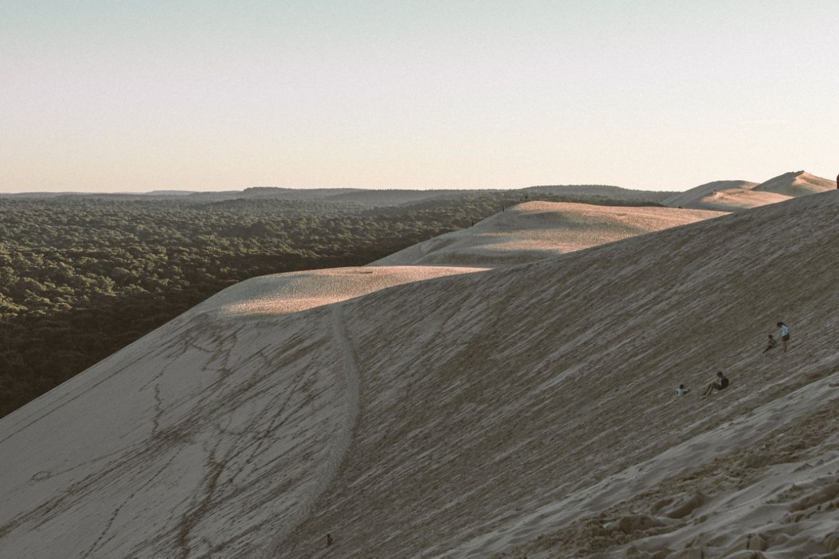
South of Brittany the Atlantic coast becomes a straight line of dunes and pine forest down to Spain, broken by the Gironde and Adour estuaries. The Dune du Pilat near Arcachon, around 110 metres tall and 2,700 metres long, is the tallest sand dune in Europe, still moving inland over the forest, and the climb to its crest gives a 360-degree view over the Arcachon basin and the ocean that visitors rate best at sunset. The Mediterranean coast is shorter and more varied: the marshy Camargue delta at the Rhone mouth, the white limestone calanques near Marseille, and the mountainous Cote d’Azur further east, covered in our guide to the French Riviera beaches. Corsica adds another 1,000 kilometres of coast and the highest island peak in the Mediterranean, Monte Cinto at 2,706 metres.
Seeing France’s landforms
Several of these landforms are among the country’s most visited natural sites, and a few are worth building a trip around.
- The Gorges du Tarn: drive or canoe the canyon, stop at the Point Sublime and Roc des Hourtous viewpoints, and watch for griffon vultures. The gorge road is narrow and busy in summer, so allow far more time than the distance suggests.
- The Dune du Pilat: a short, steep climb up the sand for the panorama over the Arcachon basin, best at sunset, with bare feet and water the usual advice.
- The Cirque de Gavarnie: the walk from the village to the amphitheatre and its 422-metre waterfall, a half-day on foot through the Pyrenees National Park.
- The Chaine des Puys: the rack railway up the Puy de Dome for the view along eighty volcanic cones, the easiest way to read the volcanic landscape.
- Etretat and the calanques: the chalk arches of the Normandy coast and the limestone inlets near Marseille, both reached on foot along clifftop paths. Our overview of the national and regional parks of France covers the protected areas that hold many of these sites.
Frequently Asked Questions
What are the major landforms in France?
The major landforms in France are the Alps on the south-eastern border, the Pyrenees along the Spanish border, the Massif Central volcanic plateau, the older uplands of Brittany, the Vosges and the Jura, the lowland Paris and Aquitaine basins, and around 5,500 kilometres of coastline. Four major rivers, the Loire, Seine, Garonne and Rhone, organise the drainage.
What are the 3 main landforms in France?
The three landform types most often cited are mountains, plains and coastline. The mountains include the young Alps and Pyrenees and the older Massif Central, Vosges and Jura. The plains cover the Paris and Aquitaine basins. The coastline runs around 5,500 kilometres along the Channel, the Atlantic and the Mediterranean.
How were France’s landforms formed?
Two events built almost everything. The ancient Variscan mountain-building, around 420 to 300 million years ago, raised the ranges now worn down to the Massif Central, Brittany, the Vosges and Corsica. The later Alpine event, from around 65 million years ago, raised the Alps, Pyrenees and Jura as Africa pushed into Europe. Sediment filled the Paris and Aquitaine basins in between.
What is the highest mountain in France?
Mont Blanc at 4,807 metres is the highest summit in France and in Western Europe. It sits on the French-Italian border above Chamonix in Haute-Savoie, and the surrounding massif holds dozens of other summits above 4,000 metres.
What is the longest river in France?
The Loire at around 1,012 kilometres is the longest river in France. It rises in the Massif Central, flows north past Orleans, then turns west through the Loire valley chateau country before reaching the Atlantic at Saint-Nazaire.
What is the tallest waterfall in France?
The Gavarnie waterfall in the Pyrenees, dropping around 422 metres down the wall of the Cirque de Gavarnie, is the tallest in mainland France. It is fed by snowmelt and is at its fullest in late spring and early summer.
Are there active volcanoes in metropolitan France?
The volcanoes of the Chaine des Puys in the Massif Central are dormant, with their last eruptions around six thousand years ago. The only active French volcanoes are in the overseas territories, such as the Piton de la Fournaise on Reunion Island.
How long is the French coastline?
Mainland France has around 5,500 kilometres of coastline along the Channel, the Atlantic and the Mediterranean. Adding Corsica brings the total to around 6,500 kilometres.
Sources and Further Reading
- Institut national de l’information geographique et forestiere (IGN)
- BRGM, French Geological Survey
- UNESCO World Heritage Centre, Chaine des Puys-Limagne fault
- Parc national des Pyrenees
- Geoportail, the national geographic portal