
Iceland produces close to a third of all the lava that has erupted on Earth in the past five centuries, from a strip of land smaller than the American state of Kentucky. About 130 volcanoes sit on the surface, fed by roughly 30 active volcanic systems, and at least one of them erupts every three to four years on average. Since 2021 the Reykjanes Peninsula, a short drive from the capital, has reopened a chapter that had been quiet for about 800 years. This page maps the volcanoes in Iceland that matter most: how the island makes them, which systems are dangerous, what the Reykjanes eruptions since 2021 have done, and how to see them safely.
Why Iceland Has So Many Volcanoes
Iceland straddles the boundary between the North American and Eurasian tectonic plates, the line geologists call the Mid-Atlantic Ridge. The two plates pull apart at roughly two centimetres a year, about the rate fingernails grow, and the gap they leave fills with magma rising from below. Most of this ridge lies on the deep ocean floor. Iceland is the rare place where it breaks the surface.
A second engine sits underneath: a mantle plume, a column of unusually hot rock anchored beneath the Vatnajokull ice cap. The plume feeds extra magma into the rift, which is why the island grew at all and why its eruptions are larger than a normal spreading ridge would produce. The combination of a plate boundary and a hotspot in the same spot is close to unique on land.
The result is an island built almost entirely of basalt, layered lava flow on lava flow. Iceland is also geologically young, around 16 to 18 million years old at its oldest rocks in the east and west, with fresh crust still forming down the middle. For a wider primer on the country, our Iceland facts overview covers the basics of geography and climate.
How Many Volcanoes and Volcanic Systems Are There
The count people repeat most often is about 130 volcanoes, of which roughly 30 to 35 are considered active, meaning they have erupted since the last ice age and could again. The Icelandic Meteorological Office and the University of Iceland keep the authoritative tally in the Catalogue of Icelandic Volcanoes, which currently describes 32 active volcanic systems.
A volcanic system in Iceland is not a single mountain. It usually pairs a central volcano, often topped by a caldera, with a fissure swarm: a band of cracks and dykes that can stretch tens of kilometres across the landscape. An eruption can happen at the central volcano or anywhere along the swarm, which is why a single system can produce both explosive summit blasts and long lava-spewing fissures.
The systems cluster along several volcanic zones that trace the plate boundary across the island, from the Reykjanes Peninsula in the southwest, up through the central highlands under Vatnajokull, to the volcanic belt in the north near Lake Myvatn.
Major Volcanic Systems at a Glance
The table below gathers the systems that drive most of Iceland’s activity, with the date each last erupted. Subglacial systems are marked because their eruptions carry an extra hazard: meltwater floods.
| System | Region | Last eruption | Why it matters |
|---|---|---|---|
| Grimsvotn | Vatnajokull (subglacial) | 2011 | The most frequently active system in Iceland |
| Bardarbunga | Vatnajokull | 2014 to 2015 | Fed Holuhraun, the largest lava flow in over 200 years |
| Hekla | South Iceland | 2000 | Erupts with little warning, sometimes under an hour |
| Katla | Myrdalsjokull (subglacial) | 1918 | Overdue by its own long-term pattern; flood risk |
| Reykjanes and Svartsengi | Reykjanes Peninsula | 2023 to 2025 | Reawakened after roughly eight centuries |
| Eyjafjallajokull | South Iceland | 2010 | Closed much of European airspace |
| Askja | Central highlands | 1961 | Its 1875 ashfall helped drive emigration to North America |
| Krafla | North Iceland | 1984 | Site of the Krafla Fires of 1975 to 1984 |
The Most Active and Famous Volcanoes
Grimsvotn is the workhorse. Buried under the Vatnajokull ice cap, it has erupted more often than any other Icelandic system in recorded history, with notable blasts in 1996, 2004 and 2011. Because it sits under ice, its eruptions melt huge volumes of water that burst out as glacial floods.
Hekla, in the south, was feared enough in medieval Europe to be written about as an entrance to the underworld. Modern Iceland respects it for a different reason: it gives almost no warning. The 2000 eruption began with usable alerts of well under two hours. Katla, hidden under the Myrdalsjokull ice cap east of Eyjafjallajokull, last erupted in 1918 and has a long history of major events, which is why scientists watch it closely.
Askja, deep in the highlands, drew Apollo astronauts who trained on its lava fields before the Moon landings. Its 1875 eruption coated farmland in the east with ash and poisoned grazing, pushing thousands of Icelanders to emigrate, many of them to Canada and the United States.
Two islands show the same forces at the coast. Surtsey rose out of the sea off the south shore during an eruption from 1963 to 1967, a brand-new island that researchers have kept closed ever since to watch how plants and animals colonise bare rock; it became a UNESCO World Heritage Site in 2008. Nearby Heimaey, which people actually live on, woke without warning in 1973 and buried part of its town under ash and lava, which residents later dug back out.
Ice, Fire and Glacial Floods
Several of Iceland’s busiest volcanoes sit under ice caps, and that pairing creates a hazard with its own Icelandic name: the jokulhlaup, or glacial outburst flood. When a subglacial eruption melts the base of a glacier, the meltwater pools and then bursts free at once, sending a surge of water, ice blocks and debris across the flat outwash plains below.
The 1996 Grimsvotn eruption produced a jokulhlaup that ripped out bridges and stretches of the Ring Road on the Skeidararsandur plain in the south. Katla, under Myrdalsjokull, is watched partly because its past floods rank among the largest known, with peak flows that for a few hours rival the discharge of a major river. This is why some bridges in the south are still single-lane, and why flood warnings travel with volcanic alerts.
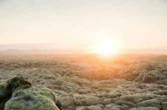
The Reykjanes Eruptions Since 2021
For about eight centuries the Reykjanes Peninsula, the tongue of land that holds Keflavik airport and the Blue Lagoon, stayed quiet. That ended on 19 March 2021, when a fissure opened at Fagradalsfjall and put on a months-long show of fountaining lava that drew tens of thousands of hikers. Two more Fagradalsfjall eruptions followed, in August 2022 and July 2023.
Then the activity shifted a few kilometres west, to the Sundhnukur crater row, the Sundhnuksgigar, beside the fishing town of Grindavik, and turned serious. On 10 November 2023 a blade of magma forced its way up under the area: a dyke about 15 kilometres long, sitting one to five kilometres down and prising the crust apart by as much as eight metres, which the Icelandic Meteorological Office tracked hour by hour. The ground tore open across Grindavik itself, and all of its roughly 3,800 residents were evacuated that day. The first eruption on the row broke out on 18 December 2023, and in January 2024 lava reached the town and burned several houses despite freshly bulldozed defence walls, the varnargardar.
Between December 2023 and 2025 the Sundhnukur row erupted nine times. From 2 January 2024 crews raced to throw up earth defence walls, the varnargardar, around Grindavik, the Svartsengi power plant and the Blue Lagoon; at their peak they ran about seven kilometres and stood six to ten metres high. They earned their keep: on 14 January the walls north of the town kept lava off the western houses even as it burned others. The ledger below tracks the main events.
| Date | Where | Scale and impact |
|---|---|---|
| 19 Mar 2021 | Fagradalsfjall, Geldingadalir | First Reykjanes eruption in about 800 years; ran for roughly six months |
| 2022 and 2023 | Meradalir, Litli-Hrutur | Two shorter Fagradalsfjall eruptions |
| 18 Dec 2023 | Sundhnuksgigar | First on the crater row; lava spread over about 3.5 square kilometres |
| 14 Jan 2024 | Edge of Grindavik | About 13 million cubic metres; lava entered the town and burned houses |
| 22 Aug 2024 | Sundhnuksgigar | The largest: a 7-kilometre fissure, 61.2 million cubic metres over 15.8 square kilometres |
| 2025 | Sundhnuksgigar | Further eruptions, a brief one in April and a 21-day event from mid-July |
As of mid-2026 the system is in its longest pause since the series began, while the ground around Svartsengi keeps rising as magma pools below. By 2025 the Meteorological Office was measuring on the order of 25 million cubic metres of fresh magma gathering under Svartsengi between eruptions, and it treats another eruption as likely rather than finished.
Eyjafjallajokull 2010 and Why Iceland Watches the Sky
The eruption that made the world try to pronounce an Icelandic name was Eyjafjallajokull in April 2010. It was not large by Icelandic standards, but it sat under ice, so it threw out fine, glassy ash, and the wind carried that ash straight over Europe’s busiest flight corridors. Aviation authorities grounded planes across the continent for several days in mid-April. Around 100,000 flights were cancelled and an estimated 10 million passengers were stranded.
The chaos pushed Iceland to the centre of global eruption monitoring. The Icelandic Meteorological Office runs a dense network of seismometers, GPS stations and gas sensors, and it issues an aviation colour code for each volcano: green for normal, yellow for unrest, orange for heightened risk or minor eruption, and red for an eruption likely to send ash high into the sky. Airlines and air traffic controllers across the North Atlantic act on those codes.
Laki 1783 and Iceland’s Great Historic Eruptions
The deadliest eruption in Icelandic history broke from a 25-kilometre fissure called Laki, or Lakagigar, which opened in June 1783 and burned for eight months. It poured out about 14.7 cubic kilometres of lava, the largest basaltic flow in recorded history, and released a haze of sulphur that killed a fifth of Iceland’s people in the famine that followed. The same haze drifted over Europe and chilled the climate for a year. The full story sits in our Laki eruption of 1783 account.
Laki had a larger predecessor. Around the year 939, the Eldgja fissure produced an even bigger lava flood, the largest of the past two thousand years, recorded in Iceland’s earliest written sources. In recent times the 2014 to 2015 Holuhraun eruption, fed by Bardarbunga, covered about 85 square kilometres of highland with fresh lava, the biggest Icelandic flow since the eighteenth century, though it killed no one because it broke out far from any town.
What the Volcano Names Mean
Icelandic volcano names describe the land plainly once you unpack them, and the suffix jokull, meaning glacier, tells you at once that ice sits on top.
- Eyjafjallajokull: the glacier of the island mountains, named for the Westman Islands offshore.
- Katla: a kettle or cauldron, an old word that also served as a woman’s name.
- Hekla: a hooded cloak, after the cloud that often caps its summit.
- Grimsvotn: the lakes of Grimur, a personal name tied to the meltwater lakes in its caldera.
- Snaefellsjokull: the glacier of the snow mountain, the cone Jules Verne chose as the way into his fictional Earth.
Lakagigar simply means the craters of Laki, the small hill the fissure happened to cross.
Living on the Hot Ground: Geothermal Iceland
The same heat that makes Iceland dangerous also runs it. Around nine in ten Icelandic homes are warmed by geothermal water piped straight from the ground, and the country generates the rest of its electricity mainly from hydropower and geothermal steam. Reykjavik heats its pavements and swimming pools the same way through the winter.
Power stations at Hellisheidi, Svartsengi and Krafla tap volcanic steam directly. The runoff from Svartsengi feeds the Blue Lagoon, the milky blue bathing site whose colour comes from silica suspended in the mineral water. At Hellisheidi, the Carbfix project pumps carbon dioxide into basalt, where it turns to stone within a couple of years, a method now studied as a way to lock away industrial emissions.
This is the practical reason Iceland invests so heavily in watching its volcanoes: the power plants, the airport and the capital all sit close to active ground.
Visiting Iceland’s Volcanoes
Volcano travel in Iceland ranges from a paved car park to a serious highland expedition. A few standouts:
- Thrihnukagigur: a dormant volcano near Reykjavik whose empty magma chamber you can descend into by lift, the only place on Earth set up to do so.
- Fagradalsfjall: a marked hiking route to the recent Reykjanes lava fields, open only when the area is declared safe.
- Lakagigar: the 1783 crater row, reached by a rough mountain track (route F206) and four-wheel drive in summer, inside Vatnajokull National Park.
- Lava Centre: an interactive exhibition at Hvolsvollur in the south, useful in any weather.
- The Westman Islands: Heimaey, where a 1973 eruption half-buried the town, now part-excavated as a museum.
One rule overrides the rest: check the Icelandic Meteorological Office colour code and the safe-travel advisories before heading to any active area, and never approach a fresh eruption without official clearance, because volcanic gas can be lethal in still air. If you are still planning the trip, our breakdown of how much a trip to Iceland costs and the guide to whale watching holidays in Iceland cover the wider itinerary.
Frequently Asked Questions
How many active volcanoes are in Iceland?
Iceland has about 130 volcanoes in total, of which roughly 30 to 35 are active, meaning they have erupted since the last ice age. The official Catalogue of Icelandic Volcanoes groups them into 32 active volcanic systems.
What is the most active volcano in Iceland?
Grimsvotn, under the Vatnajokull ice cap, has erupted more often than any other Icelandic system, most recently in 2011. Because it lies under ice, its eruptions also trigger glacial meltwater floods.
Is it safe to visit Iceland with all the eruptions?
Yes, for almost all travellers. Eruptions are closely monitored and usually confined to small, fenced-off areas, while Reykjavik and the main ring road stay open. The Reykjanes events have not closed Keflavik airport. Always follow the official colour code and local advisories.
Which Iceland eruption stopped flights across Europe?
Eyjafjallajokull in April 2010. Its fine ash drifted over Europe and grounded around 100,000 flights, stranding an estimated 10 million passengers over about a week.
Are the Reykjanes eruptions over?
Not necessarily. Nine eruptions struck the Sundhnukur area between December 2023 and August 2025, and although the system later paused, the ground keeps rising as magma collects. Scientists expect further activity rather than a clean end.
Can you go inside a volcano in Iceland?
Yes. At Thrihnukagigur, near the capital, visitors are lowered about 120 metres into the empty magma chamber of a volcano dormant for roughly 4,000 years. Tours run in summer only.
Sources and Further Reading
- Icelandic Meteorological Office – monitors every active volcano and sets the aviation colour code used across the North Atlantic
- Catalogue of Icelandic Volcanoes – the official 32-system database compiled by the University of Iceland and the Met Office
- Almannavarnir, Department of Civil Protection – hazard zones, evacuation orders and the Grindavik response
- Smithsonian Global Volcanism Program – eruption histories and dates for every Icelandic volcano
- Vatnajokull National Park – visitor access for Grimsvotn, Bardarbunga and the Lakagigar craters
- University of Iceland, Institute of Earth Sciences – research on magma movement and the Reykjanes dyke
- SafeTravel Iceland – official safety advisories to check before visiting any active site
- Vedurstofa Islands, Reykjanes eruptions (Icelandic) – eruption bulletins and ground-deformation readings for the Sundhnuksgigar